Showing posts with label peru. Show all posts

Friday, January 23, 2009

Last day in Lima

Throughout my trip I've been very fortunate to have Gean Carlo's family's house as my home base in Lima. On the 19th, I took an early bus back across the border to Peru, returned to Puno, went out to the airport in Juliaca and then flew back to Lima. It was so nice to be greeted by the family, all excited to hear about my journeys since I'd left over a week before.


Aaron was particularly excited to see his "Tia Leah" (Aunt Leah)
and play with her camera

That evening we just hung around the house and I shared photos and stories. The next day, which was ultimately my last day in Peru, Emily (Gean Carlo's daughter) and I went off to the beach at Miraflores. We had been to Miraflores before with Gean Carlo, but hadn't ventured down to the beach. One of my favourite parts of this day was taking a minibus across town. I still don't have any idea how this system works (and Emily wasn't really able to explain it either), but it did get us there and was very entertaining along the way. The constant yelling and advertising of the "doorman" who was hanging out the side of the van, along with the various patrons of the bus, all contributed to my amusement.


El Beso statue in El Parque de Amor, Miraflores
The Kiss Statue in The Love Park, Miraflores


The beach in Lima


The fancy Marriott Hotel overlooking the Pacific Ocean and the beach


We hung out on the beach for a little while, enjoying some ice cream and the occasional bit of sunshine. When it was time to ascend back to Miraflores, Emily insisted we take the path that was fenced off and stated "Peligro" (Dangerous). There were a few people doing the same so we knew it was passable, but we couldn't really see the condition of the path past half way up. Sure enough, the stairs were there, but a lot of the way they were covered with rocks, which had obviously slid off the side of the hill and deemed the trail unsafe. Emily struggled up the path in her flip flops, but we did finally make it to the top.


A little sweaty after our hike up the hillside


Beach View

Next we went back over to Parque Union and bought a few final touristy mementos for me and then went to the grocery store. I had told Gean Carlo's mother Teresa that I would make dinner for everyone that night, so Emily and I had to go get the cooking supplies. Chinese food, or chifa, is very common around Peru, so I thought I'd try making them some Japanese food: yakisoba. It's a pretty simple stirfry of cabbage, carrots, bok choy, peppers, tofu, ginger, noodles and a few other things. I managed to find everything I needed, including "tofu cheese", as it was labeled. Dinner was a success and fun to prepare and enjoy with everyone. I even got Aaron to help out with peeling the garlic, keeping the work area tidy and helping to put things in the pot. It was reminiscent of my days of teaching the Boys Cooking Club in Vancouver- so fun.

That evening Juan (Gean Carlo's father) arranged for someone down the street to come and pick me up the next morning at about 5:00 am to take me to the airport for my 7:30 am flight back to the USA. Sure enough, he still had to go knock on the guy's door the next morning at about 5:15 to wake him up... Nina, Emily and Juan were all up bright and early to see me off to the airport. Teresa had already assured me in conversation the night before, when I was explaining to her the various "homes" I had in Vancouver, Santa Cruz, Salmon Arm and Montreal, that this could be my home in Peru. What a wonderful family.

Time to get back to my not-so-real real life....


Tuesday, January 20, 2009

Finally Getting to Puno: Lake Titicaca

So before I mentioned the troubles I had in getting to Puno the first time (see this post), which involved a road closure and returning to Cusco. A Kiwi guy named Tim and I ended up teaming together and figuring the next bus we could possible take was overnight to Puno. We visited one bus company and the boy told us that the bus would leave at 11 pm and arrive in Puno about 5:30 am. I got his phone number so that we could call before coming out to the bus station and be sure the highway was open again and the bus was leaving. That’s the day I spent bumming around Cusco visiting a few museums. Tim and I went for dinner and then back to the hostel we had stashed our bags at for the day to call the bus company. I called about 10:15 pm and asked if the bus was still going to leave at 11 pm. “Yes, the bus is leaving at 10:30 pm” is the answer I get. What? I clearly had it written down on this piece of paper that it was leaving at 11 pm, but now the guy insisted that it was leaving at 10:30 pm. “Are you coming to the station?” he asks. “Well, we’re going to try!”

We threw our backpacks into a taxi and sped off to the bus station. I left Tim to carry in the backpacks and pay the cab when we arrived and I dashed into the station. Tim’s Spanish is pretty minimal, so it was best I run ahead. Sure enough the bus was getting ready to leave and unfortunately it was also full. I guess everyone else had gotten the right information. The girls at the counter were speaking quickly between eachother and then made a suggestion to me that we could take a taxi somewhere to catch another bus. I wasn’t sure if I was understanding. Either we were catching up with a bus that had left the station earlier or we were going to a different station to catch a bus that was also leaving soon. They were speaking really quickly and were on and off the phone with whom I assume was the driver of the other bus. There were definitely two empty “cama” (bed) seats available on that bus. Tim comes hobbling in under the weight of both of our huge backpacks as I’m paying for our tickets and then we are rushed out the door to another taxi to take us to another bus. We’re still not entirely sure what’s going on but the girl told the taxi driver where to go, so we were in his hands. Of course he then chooses this time to announce he’s going to be charging us way too much for the ride, to which we protest but have to agree as we don’t have any other choice. I insist that he at least goes quickly. And quickly he does. One of those situations where you think about “it’s a good thing Mom can’t see this happening right now”. The driver erratically drove down the road and about 10 minutes later announces “San Luis!” as we pass a (our) bus. Sure enough, it had left the station about 30 minutes earlier and we had caught up to it! The taxi driver passed the bus and then dropped us off at a random bus stop about 5 minutes ahead. We were now in the San Jeronimo neighbourhood of Cusco, not a lot of tourists here! We waited for what seemed like too long, but finally the bus showed up. We flagged it down and got on. Talk about adrenaline rush! I wasn’t really sure what was happening there, but somehow it worked out. It took me a while to calm down and fall asleep… although Tim managed to do so right away.


Exploring Lake Titicaca

When we got of the bus there were people ready to maul us and convince us to go on their Lake Titicaca tour that day. One thing about tourism in Peru is that the companies are quite aggressive. A representative is always right there when you get off the bus/plane to set you up with a place to stay and as many tours as you’re willing to do. It’s somewhat useful, but if you have no idea of what to expect or look for you also don’t know if you’re getting ripped off. I had looked into the day tours of Lake Titicaca a little before leaving so I knew that they could cost $15 to $30, depending on whether lunch was included, etc. Sure enough, one man latched onto Tim and I and even went so far as to ride in the taxi with us to the hostel. The package he was offering included a visit to Uros Floating Islands and then to a natural island called Taquile, pick up and drop off at the hostel and a bilingual guide for the trip. All of that for 35 soles (3 soles ~ $1 USD, so about $12 USD). There would be a stop for lunch, but that would be paid separately. I thought it was a pretty good deal. Tim was hesitant. He’s traveled to a lot of different countries and is a little more wary about being ripped off. It seems like you have to worry a little less about that sort of thing in Peru (like the guy isn’t going to just take our money and run) and so I figured we should take the deal. Money exchange, paper signing and Luis was off to find his next victim. All this and it was still only 5:45 am. We had time for about an hour of restless sleep in the hostel living room until our pick up time.

Los Uros

Our boat left the Puno harbour at about 7:30 am and headed straight for Los Uros, the Floating Islands. There were about 25 people on our boat, mostly older, but a few groups about my age. The boat was slow, but it was nice to take in the scenery of the island. Lake Titicaca is the “highest navigable island in the world” (although I’ve read there may be higher ones in Bolivia and Ecuador). I’m still not entirely sure what they mean by navigable (what lake is unnavigable?) so if you do, let me know. The altitude of Lake Titicaca is 3,810 m and covers an area of 8,550 square km. The deepest point is 283 m. Sixty percent of the lake is in Peru, while 40% of the lake falls within the Bolivian border.

The Floating Islands are a network of about 40 islands and have a population of 2000 people. The islands are actually made up of “totora” reeds and are completely floating! The base is chunks of totora root and then there are layers upon layers of totora reeds on top of the roots to form the island. Every two weeks they have to almost completely rebuild the island because there are parasites in the reeds that break them down. It’s like a constant work in progress. Each island is home to about 10 families and their houses are also made of totora. Their main livelihood is fishing and artisan crafting.

We visited Chumi Island and two men about 6 women and children were there to greet us. The rest of the island’s people were out fishing and/or at school, but these folks had stayed behind today to show us around their place. The president of the island, identifiable by his special toque, gave a short presentation on how the islands are constructed and what life on a floating island was like.

Chumi Floating Island

An intricate tapestry made by one of the women of the island that describes life on the island.
If I had a house, this would definitely be an interesting wall hanging.


Unfortunately, due to the humidity of living on a reed island, many of the older residents suffered from rheumatoid arthritis. The life expectancy for these people was only abot 60 years old and it’s quite likely that they’re unable to walk for the last 5 to 10 years of their life. It was interesting to learn (later on, when we were back in our tour boat) that the population of these islands was diminishing because young adults were moving to the mainland to enjoy a better quality of life. However, another community of islands that does not accept tourism was not experiencing this phenomenon, as the children are not exposed to the outside world in the same way.

We had a chance to wander around and explore their simple but well built living spaces and purchase crafts from the women. The president threw a rope tied to a rock off of the edge of the island and asked us to guess how deep it was (between 5 and 20 metres). I guessed right on at 17 metres deep and won a mini totora boat necklace.

I don’t think she made any of those necklaces,
but she sure was convincing to get people to buy them


There aren’t any electrical lines going out to the islands,
but they do collect solar power to give themselves a few extra hours of light everyday


The view from the lookout tower on the island


Neighbouring Floating Island


After the presentation we went on a ride in one of the big matrimonial boats to the island across the way, where we met back up with our tour boat and headed on our way to Taquile.


This matrimonial boat can hold up to 40 people


Waving goodbye to the people on Chumi Island


Taquile

On this natural (hard land, not made of reeds) island, we did a lot of walking. The first ascent definitely has us huffing and puffing up the stairs, again. Seems like a pretty common theme to this week!


More hiking at high altitudes


This is what the paths look like on the island-
of course there are no roads or motorized vehicles


We stopped at a local house that had a nice layout of picnic tables and tents for us to eat lunch.
Lunch was delicious. We started out with my new favourite Andean soup: quinoa soup. Quinoa (pronounced keen-wah) is a grain native to the Andes that I do often eat at home, although had never thought to put in soup. The soup also featured a new-to-me herb called muna that has a fresh minty taste. Next, we got to choose between a tortilla (omelette) or trucha (trout). Tim ordered the trout, so I got the omelette- that way I’d be able to try both! Both dishes were very fresh and tasty. Of course we also had a gorgeous view of the lake, which may have heightened our sesnses a little.


Our lunch table view


Tim and I enjoying our omelette and trout


After lunch we walked up to the main plaza, took a few photos, wandered around, and then headed down the other side of the mountain to the opposite dock, where our tour boat was waiting. The walk along the rock walkways was definitely easier from the top down and we were better able to enjoy the views. What a gorgeous, peaceful spot.


This marker in the main plaza confirmed I was pretty far from home…
6886 km from Montreal and 6302 from NYC


On the island the boys and men knit their own toques and belts.
This little boy is sitting on the steps near the plaza working on a new toque


Heading back down the opposite side of the island to the boat dock


The locals always burn by the tourists on the paths, be it going up or down


On the slow two hour ride back to Puno we enjoyed the sun on the top of the boat and chatted with some Swedish girls who had made their way to Puno via Bolivia. They had done a four day tour of the high altitude salt flats there (another place I definitely want to see at some point) and had some interesting stories. Life is pretty good.

Monday, January 19, 2009

Sacred Valley Tour

Day 3 in Cusco I did the Sacred Valley Tour (last Tuesday, Jan 13), which takes you out of the city and to some interesting ruins and sites. There was a mini-bus of us on the tour, about 12 people all together and Karem was our guide for the day. The tour was in English and Karem’s English was definitely not bad. However, it sort of seemed like she was rehearsing it all, almost like a robot. Like she had every single line memorized! It was a little strange, but at least she had it all covered.


Chinchero

Our first stop was about 30 minutes out of the city, to a colonial city called Chinchero. Chinchero was once an Incan settlement that was invaded by the Spanish. The site has an interesting mix of Incan ruins, and then colonial/Incan architecture.

Children watching all the tourists puffing up the hill


The main plaza was also filled with local women selling different textiles and souvenirs


The most interesting part of this stop was going to the Textiles Workshop. They demonsrated the whole process of cleaning, spinning, dying and weaving the llamas wool. They use a variety of resources for natural dyes including fruit, flowers, plants and even cactus parasites. Adding salt to a colour can also change it so you get different shades.


Washing the wool with a natural soap from a plant root


Natural Dyes


Dying the spun wool


Weaving the textiles


Every feature of the pattern along the edge of the textiles represents something to the Andean people. From the mountains, to the sun, to the puma and snake, which are important animals in their religion.


Guinea Pigs
More on Peruvian food later, but I did catch this photo of a few guinea pigs outside one of the houses in Chinchero. “Cuy” is a typical Peruvian dish. Guinea pigs are definitely not considered pets in this country!


Despite having to spend a few hours in the tourist bus that day, it was actually quite enjoyable. The scenery along the way was gorgeous. Rolling hills of farm land with amazing mountains in the backdrop.


Moray

Our next stop was Moray- a very impressive agricultural site that consists of a huge crater of terraces. There are actually 4 or 5 of the craters in the area, but we only visited (and climbed down) the largest one. It was 90 metres deep! Again, different parts of the crater and areas of the terraces would have been home to different crops due to the varying microclimates.


These “stairs” enabled the farmers (and us!) to climb down the terraces. Each level of the terrace was probably 4 to 5 feet high.

Needless to say, the walk back up out of the crater took some time….


Ollantaytambo

Definitely my favourite stop of the day was at Ollantaytambo. Ollantaytambo was once part of Pachacuti's Incan Empire and features extensive farm terracing and irrigation where it is situation in the Urubamba Valley. During the Spanish conquest, the site then served as a base for Manco Inca, the primary resistor of the conquistadors, after Cusco had since been lost to the Spanish. In the 1500s, Manco Inca even managed to defeat a Spanish expedition from the site, which was an important victory at the time.
Ollantaytambo now contains some of the oldest continuously occupied dwellings in South America.

Yet another hike at 2,800 m above sea level


Typical Incan architecture


More Farming Terraces


See the face carved into the side of the moutain here (above)? The face is looking to the left and is located on the same level, to the left, of the four rows of lighter stone. This is pretty interesting, hopefully I can explain it properly. One recurring theme in the Incan culture is the Sun. They worshiped a sun god (Inti) and also tuned into the sun and its cycles to help with their agriculture. On the 21st of June (the southern hemisphere's winter solstice), the sun perfectly hits this face on the side of the mountain as seen from Ollantaytambo and the Temple of the Sun and marks the beginning of the sun festival.


The fountain in the Sun Temple

One of the crazy stories behind this ruin is that the quarry where all of the rocks came from is on the next mountain over, 4 km away! The Incans rolled the rocks down the hill from the quarry, somehow got them across the river in the valley, and then waaaay up the next mountain again. An English guy who was in my tour group made the observation: “Why wouldn’t they just build it on the mountain where the rocks came from? That makes more sense to me…” Good point.

Machu Picchu "The Lost City of the Incas"

Last Monday I think I took the longest "day trip" of my life. But it was to Machu Picchu, so it made it okay. But for future reference, if anything takes as long as 4.5 hours to get to, it should no longer be considered a day trip.


Crazy Train

I was picked up from my hotel at 6:30 am so we could catch the 7 am train to Aguas Calientes. The train was an experience in itself. We set out from the station and less than 10 minutes later the train comes to a halt that makes most people jump a foot off of their seats. Then, a few seconds later, it clunks back to a start... in the direction we had just come from? All of the passengers are looking around at eachother "What the heck is going on?" Then the attendent comes along and tells us that we've actually switched to another track, that switches back the other way. Essentially we have to make zigzags up and over the mountains- back and forth, back and forth. Sure enough, another 10 minutes later, another rough stop, then start. So much for sleeping on the train... Thankfully the switchbacks didn't go on for the full four hours, but there were about 6 in the first hour and a bit.

Way up there

The altitude of Cusco city itself is about 3,400 m (~11,000 ft). It's quite common that people experience "altitude sickness" when they first arrive there, which involves feeling dizzy, tired and out of breath due to the decrease amount of atmospheric oxygen at this altitude. The day I arrived I was exhausted and feeling pretty sick, so I slept all day and feel anything that was discernibly altitude sickness. Machu Picchu itself is at 2350 m (7,970 ft) which is slightly lower of course, but still pretty high. To give you Salmon Arm folks an idea, SA is at 415 m (1,360 ft)- quite a difference. Even Rogers Pass (in the Rocky Mountains between Vancouver and Calgary) is only at 1,300 m (4,360 ft).

So when you start walking around Cusco or Machu Picchu, say up a few steps, you can definitely feel it. But everyone's huffing and puffing, so it's okay. This is where the coca plant comes in. Andean people both make tea out of and chew coca leaves to help them deal with the altitude. No, there is no “drug” effect, but it is also supposed to help to suppress hunger and tiredness. For these reasons it is very often used by those who work at this altitude. I was also very interested to learn it is high in calcium and proteins. Subsequently, osteoporosis is non-existent in these populations. I actually still haven’t tried chewing the coca leaves, but I do love the Mate de Coca tea and the coca caramels.


First Glimpse

I found my "Orange Flag" man when I got off the train in Aguas Calientes, as instructed by the guy who had taken me to the train station. He whisked me and three other people off through the crowd and to where the buses leave to go up the mountain to Machu Picchu. I was already starting to get a sense of chaos at this point. Hundreds of people had just arrived by train and probably 95% of them were headed in the same direction as I was. The bus filled up quickly and then started up the mountain. Many switchbacks and blind corners later (I wonder how many bus accidents happen on that stretch…?) we arrived at the control gate to Machu Picchu. I joined the orange flag group and our enthusiastic guide and we headed through the gates. Around the corner and here is what you first see:


Machu Picchu, meaning old mountain is actually the name of the mountain that this “Lost City” is located on. The city was built in the 1400s A.D and was the home of approximately 1000 Incans and their ruler Pachacuti. The Incas are known for their architectural skills, agricultural abilities and astronomic interests. The entire “city” is built with huge rocks that are carved, shaped and assembled as bricks with amazing precision. Going up the side of the mountain are terraces that look like giant steps. The rock walls retain not only provide the space to grow the crops, but also prevent erosion of the land. The idea of these terraces is that each has its own micro-climate, which is preferred by a specific crop.
The reason this is called the “Lost City” is that it was actually never found by the Spanish Conquistadores who arrived in the 15th century. As they took over the Incan empire, the Spanish forced their Catholic religion onto the Incan people as well as destroyed or at least damaged many of their cities, temples and structures. The city at Machu Picchu remained untouched until an American archeologist came across it in 1911 when he was led their by a local guide and a small boy. Since then there has been a great amount of archeological research on the site, including the recovery of thousands of tools and artifacts, most of which are in a museum at Yale University in the States. There has also been a good amount of reconstruction and restoration of the site. It is now considered one of the Seven Wonders of the World.

Despite the chaos, I was happy to be part of a guided group. It is definitely a good way to get more information and a better understanding the ruins. This way you can also be sure to see all of the major points of interest. Below is only a fraction of the 150+ photos that I took in the three hours that I was at Machu Picchu, but I think it’s a pretty good representation of what I saw.


Pouring Rain

Right now is Peru’s summer, but it is also the rainy season in the mountains. Unfortunately, within 10 minutes of getting in, it started to pour rain. I had opted to not buy one of the plastic “ponchos” that were being sold down below and brought some extra clothes instead. Unfortunately, I hadn’t thought far enough ahead to bring my rain jacket from home…
Take a look at this photo: one interesting thing that came of it dumping rain was that you could see how the Inca’s drainage system worked- look at the water pouring out of this one hole in the wall (top left corner).


Rainbow of Ponchos


Temple of the Three Windows
The rocks used to build the temples are very squared and the corners fit snugly together. They did not use any sort of mud or mortar between them. However, there are some copper and metals dowels to hold the rocks together.


Regular (non-temple) walls
About 95% of the city is built with this less-precise architecture- though still very strong and sturdy.
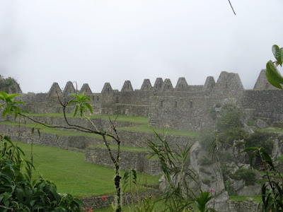
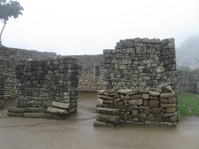


The Ruler’s House

Lonely Tree


The next mountain (right) is called Waynu Picchu, the young mountain. You can also hike up to the top of it and get a different view over Machu Picchu. They have recently begun restricting the number of people that go up each day to 400 and apparently it had already “filled up” at 8 am that morning. Many people come up the day before and spend the night at Aguas Calientes so they can take the early buses up to Machu Picchu and catch the spectacular sunrise and usually clear skies.


The Farming Terraces


Many of the buildings at Machu Picchu did originally have roofs, however only a few have been reconstructed as a demonstation.


Llamas graze on the terraces


After finishing the 2 hour guided tour, I wandered around for another hour by myself. The rain had scared off the majority of people and quite quickly it was much much quieter. I walked up to the lookout point, which we had not done on the tour. At a lower altitude it probably only would have taken about 5 minutes to ascend, but I found myself having to take about 3 breaks on the way up. It’s a really strange feeling to be so winded when you know you’re not really physically over-exerting yourself!


Some encouragement


So the rain did stop after about 45 minutes, but then the fog rolled in. It was actually pretty amazing to stand at the top of the look out and watch the fog roll over the city. At some points it was almost impossible to see anything below.


Looking down into the valley towards Aguas Calientes


Fogged In


Overall, seeing Machu Picchu was a pretty magical experience. I did enjoy the guided tour, but also appreciated having some quiet time afterwards to take it all in. It’s too bad the weather wasn’t nicer, but there was something pretty mystical about the fog and clouds.

I took the bus back down to Aguas Calientes and arrived about an hour and a half before my train was scheduled to leave to go back to Cusco. I had some lunch and then wandered around the market near the train station. It was amazing how much stuff they had for sale! Sweaters, blankets, socks, toques, gloves, jewelry and all sorts of trinkets and souvenirs.

Goodies and souvenirs hanging from every possible place


Flutes!
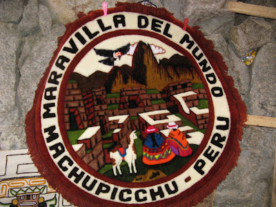


The train pulled out right on time at 5 pm. When we finally made it back to Cusco and were making the switchbacks down the mountainside, the view of the lights was spectacular. Cusco is a huge city with about 300,000 habitants (and who knows how many thousands of tourists!) and the lights sprawl up into the mountains. By the time I got back to my hotel it was almost 10 pm, about 16 hours after I’d left that morning. A long, but satisfying day.